FTTH GIS
Geolocate your FTTH deployments
FTTH GIS Module
This new advanced module will allow operators to geolocate their FTTH deployments, drawing all their elements on different maps or filtering only for those that we need to visualize. In addition, they will be able to quickly see the free outlets of a CTO as well as the clients connected to them, thanks to the TOTAL INTEGRATION with the ISP Gestión Client Devices.
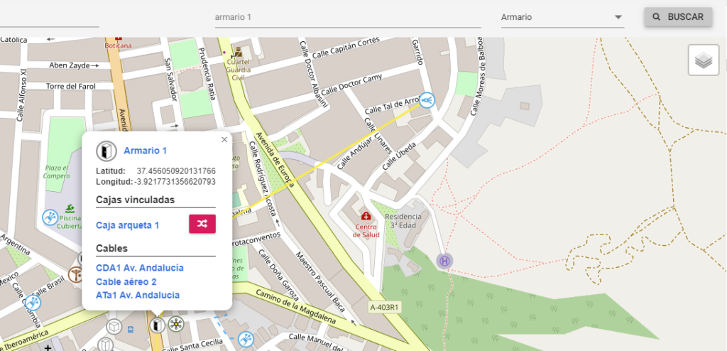
With FTTH GIS, if the operator already had the elements of its network inventoried in ISP Gestión, it will now see them geolocated on the map, thus facilitating their maintenance. And you will also be able to consult the splice charts so that your technical department knows how the fibers are fused within a CTO
In addition, with the activation of this advanced module we will have the possibility of registering the fiber elements that make up our FTTH network in a visual way, obtaining the graphic representation on a map of said network.
Once activated, in the Technical Menu of our application we will see the new entry CHALK. When we press it, it will open a new tab in the browser to be able to view it in full screen.
GIS SOFTWARE FEATURES
Working with our GIS in FTTH deployment offers significant advantages in terms of efficient planning, informed decision making, resource optimization and asset management. These advantages contribute to faster, more cost-effective and more reliable deployment of the FTTH network, which in turn improves the quality of communication services and user satisfaction.
Network Selector
Layer Picker
map types
item finder
cable templates
Integrated with ISPGestion
Advantages of working with FTTH GIS
GIS FFTH offers a number of important advantages, including:
Efficient planning and design: The use of GIS enables more efficient planning and design of the FTTH network. GIS allows visualization and analysis of geospatial data, which facilitates the identification of suitable areas for network deployment. This helps optimize FTTH network design by considering factors such as population density, topography, physical obstacles, and the location of existing infrastructure.
Informed Decision Making: GIS provide analytical tools that enable informed decisions during FTTH deployment. By integrating geographic data with information about service demand, resource availability, and legal and environmental constraints, professionals can evaluate different scenarios and select the most viable and cost-effective option.
Optimization of routes and resources: GIS allow optimization of FTTH network installation routes, which reduces costs and implementation time. By analyzing existing geographic features and restrictions, optimal routes for cable and equipment installation can be determined, minimizing the need for subsequent modifications. In addition, GIS helps to efficiently allocate resources, such as personnel and materials, to maximize productivity and minimize response times.
Asset management and maintenance: GIS facilitate the management of FTTH network assets throughout their life cycle. By incorporating location data, technical characteristics, and maintenance records into a centralized GIS system, assets such as cables, equipment, and connections can be more accurately tracked. This allows for better maintenance planning, quick identification of problems and a more efficient response to potential breakdowns.
Integration with other technologies: GIS can be integrated with other technologies used in FTTH deployment, such as project management systems, computer aided design (CAD) software, and inventory tracking tools. This integration improves efficiency and collaboration between the different teams involved in the FTTH project, while reducing errors and duplication of efforts.